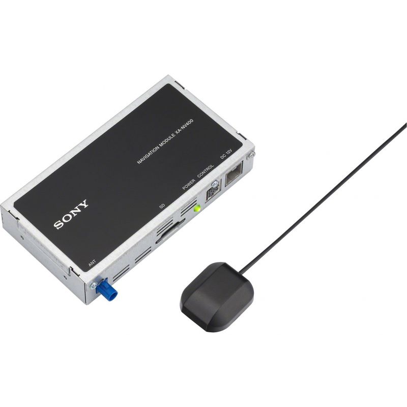


Sony XA-NV400 - In Car Navigation TomTom Add on Module

Add Navigation to your Sony Media car stereo.
£269.99
Add Navigation to your Sony AV car stereo.
Plug the XA-NV400 navigation module into a compatible Sony DVD receiver, then hit the road with powerful navigational tools just a touch away on your receiver's screen. The module comes with everything you need for connecting it to your receiver, and uses TomTom's advanced NavApp engine for simple touchscreen setup and use. You'll be ready to roll with easy, interactive route and destination finding.
Main Features
- add-on navigation system for select Sony DVD receivers
- includes a GPS satellite antenna with cable
- utilizes TomTom NavApp technology
- advanced lane guidance
- maps displayed on receiver's video screen
- 2-D and 3-D map views
- route customization options
Head Unit Compatibility
The Sony XA-NV400 add-on GPS navigation module is compatible with Sony's XAV-V631BT digital media receiver and XAV-W651BT DVD receiver (both sold separately). It simply plugs into the receiver's rear-panel proprietary multi-pin port labeled "EXT". The add-on GPS module's map screen will display on the Sony receiver's touchscreen monitor and voice prompts will be heard through your vehicle's speaker system. You will use the head unit's touchscreen monitor to operate the XA-NV400's navigation functions.
TomTom Navigation Software & Maps
The Sony XA-NV400 add-on GPS module features TomTom navigation software & maps. TomTom navigation incorporates real world, real-time feedback, providing accurate mapping information. Maps are installed on the included SD memory card. You must install the SD memory in the XA-NV400 prior to using navigation functions.
GPS Antenna
The Sony XA-NV400 add-on GPS navigation module includes a GPS antenna which is mounted inside the vehicle; either on the front dash or back deck. The GPS antenna features an attached 10' cable and comes with a self-adhesive mounting pad. The GPS antenna measures 1.4375" (w) x 0.5625" (h) x 1.5625" (d). The mounting pad measures 3.1875 (w) x 0.0625" (h) x 3.1875" (d).
On-Screen Map
Once the XA-NV400 add-on GPS navigation module calculates your route, the map screen will appear on your compatible Sony receiver's LCD touchscreen monitor. The map screen displays a real-time moving map illustrating your current position and intended route. Your route is marked with a red line, while a blue arrow represents your current position, and a checkered flag marks your destination. As you travel, the XA-NV400 guides you to your destination with arrows and directions on the map. You can choose between a 2D or 3D map screen with a Day, Night, or Auto color mode.
Instruction Panel
The Instruction Panel at the top of the map screen shows the direction of your next turn, the distance to your next turn, the name of next road on your route, and Lane Guidance at some junctions.
Route Bar
The Route Bar is shown on the right-hand side of on-screen map when you have planned a route. It has an arrival Information Panel at the top, and a bar with symbols underneath. The Information Panel indicates estimated time of arrival at your destination and the length of time to drive to the destination from your current location; parking is also shown near the destination when there is parking available. The Route Bar also uses symbols to indicate stops (waypoints) along your route, as well as POIs (like petrol stations, restaurants, hotels, & rest areas). The symbols will be in the order they occur on your route. The bottom of the Route Bar represents your current location and shows the distance to the next incident on your route.
Lane Guidance
Lane Guidance helps you prepare for highway exits and intersections by showing you which lane you should be in.
Speed Panel
A Speed Panel is integrated into the on-screen map at the bottom. The Speed Panel indicates the speed limit at your location, your current speed, and the name of the street you are driving on. If you drive more than 3mph over the speed limit the speed panel turns red. If you drive less than 3mph over the speed limit the speed panel turns orange.
Text-to-Speech
In addition to the map screen, the navigation unit features loud and clear spoken instructions through your vehicle's speakers. When driving to your destination, the XA-NV400 will announce turn-by-turn directions, including street names and road numbers. You can choose between male and female voices in various languages. Your source audio will attenuate, while turn-by-turn instructions are heard through your vehicle's speakers.
Drive To Menu
The Drive To Menu is the simplest and most useful starting point in most situations. Given your current GPS position, you can use this menu to navigate to any given address, favorite location, recent destination, POI (Points Of Interest), and so on. You can choose from the following options.
Quick Search
Using an on-screen text box and keypad you can search for a specific or partial address, a postcode or city, a type of place or a place by name, a POI (Point of Interest), or coordinate (Latitude/Longitude).
Home or Work
Once your home and work location are stored in memory, they can be quickly chosen as a destination.
Recent Destination
You can display a list of addresses, Points Of Interest, and other destinations that you've used recently.
My Places & Routes
The locations that you visit frequently and the routes that you plan can be stored as "My Places" & "My Routes", so you have quicker access to them.
Parking & Gas Stations
Planning & Modifying Route
You can plan a route with a start and end destination, plus stops (waypoints) in between. You'll be able to review a list of turn-by-turn instructions of your planned route, plus simulate the planned route on the on-screen map. You can also make changes to route by clearing the entire route, skipping to the next stop along your route, finding an alternative route, avoiding a blocked road, avoiding part of the route, avoiding toll roads/ferries/unpaved roads, and by adding stops (waypoints).
Route Types
You can select the type of route planned to your current destination. Choose from Fastest Route, Shortest Route, Most Eco-Friendly, or Avoid Interstate/Highways.
Avoidances
You can choose to avoid some features that are on your currently planned route. You can avoid Toll Roads, Ferries, Carpool Lanes, and Unpaved Roads.
Adding/Deleting A Stop (Waypoint)
You can add stops or waypoints along your planned route in between the beginning and destination of the route. You can also delete stops (waypoints) within your calculated route.
Detour
If there is a blocked road on your route you can change your route to avoid it and detour around it. If only part of a road is blocked or you wish to avoid part of a route, you can select a specific section of a route to detour around. A new route is found that avoids the blocked road or section of route. You may get shown up to two alternatives depending on the road network between you and your destination. The new route is shown on the map view with the difference in travel time.
Touchscreen Gestures
The Sony XA-NV400 add-on GPS module offers touch and gesture control from your compatible Sony receiver's touchscreen monitor. You get tap, drag, flick, as well as press & hold touchscreen gesture control.
Power/Ground Wiring Harness
In addition to the proprietary cable which runs from the XA-NV400 to the compatible Sony receiver, the add-on GPS navigation module includes a power/ground harness which will need to be connected to +12V switched accessory power, +12V constant power, and chassis ground.
| type | N/A |
|---|---|
| manufacturer_part_number | N/A |